Walk 7 Wednesday 3 April
|
|
Distance: 22 miles (circular)
Duration: Allow the whole day Difficulty: Strenuous; lots of ascent/descent and stiles Bring: Picnic, drinks and a camera. Opportunity to resupply at 11.5 miles and optional pub visit at the end. Meeting Point and Parking: 8:30am at Lower Wireworks car park, Forge Road, Tintern NP16 6TQ SO526001 ///initiates.reviewed.inclined This walk is not suitable for dogs |


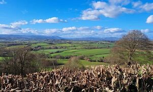
This challenging walk for the very fit will have an elevation gain of 4000ft and will visit the next highest point west from the Harz Mountains in Germany, the home of a Led Zeppelin rock god and a castle in England. It will explore lesser-known paths as well as the Wye Valley Walk and Offa’s Dyke Path.
Walk 8 Wednesday 3 April
|
|
Distance: 3 miles (circular)
Duration: Allow 1-2 hours Difficulty: Easy (shorter option available) Bring: Drinks and a camera Meeting Point and Parking: 10:00am at Offa's Dyke car park, off the B4228 Coleford Road at Tidenham Chase GL15 6PT ST558992 ///glow.assures.everybody This walk is not suitable for dogs |


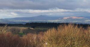
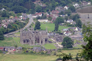
A figure of eight walk with no stiles walking the Offa’s Dyke Path to the Devil’s Pulpit for the iconic view of Tintern Abbey. Option to carry on through Poor’s Allotment across the nature reserve with views over the Severn Estuary before returning to the start.
There is no charge for this walk, however places must be booked.
There is no charge for this walk, however places must be booked.

Walk 9 Wednesday 3 April
|
|
Distance: 9 miles (circular)
Duration: Allow 5 hours Difficulty: Moderate to Energetic with steep and gradual ascent/descent, steps and stiles Bring: Picnic, drinks and a camera Meeting Point and Parking: 10:00am at Cadora Woods car park, Stowe Road, St Briavels GL15 6QG SO543055 ///tidying.lyrics.bath Public Transport: Service 69 (Chepstow to Monmouth via Tintern) has a stop at Bigsweir Bridge, which is just a short walk from the meeting point. See Traveline Cymru for details. This walk is not suitable for dogs |


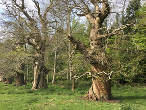
Gorgeous woodland and a riverside walk admired by poets. Starting in the English Forest of Dean, we eventually walk through ancient Sweet Chestnuts descending to cross the Wye into Wales. We then climb to Cleddon falls, admiring the views experienced by Victorian tourists. After descending to Llandogo (famous for its Trow building and millstone transportation) our route returns along the meadows of the River Wye.
Walk 10 Wednesday 3 April
|
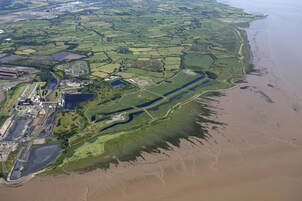
|
Distance: 6.5 miles (circular)
Duration: Allow 4-5 hours Difficulty: Moderate, flat terrain Bring: Picnic, drinks and a camera, binoculars if you have them Meeting Point and Parking: 10:00am at Newport Wetlands Visitor Centre, West Nash Road, Nash, Newport NP18 2BZ ST334834 ///above.march.copper. Parking charges apply (free for RSPB members). Public Transport: Newport Bus service DRT63 connects Newport bus station to the Visitor Centre. Please note this is a demand-responsive service which must be booked in advance - visit the Newport Bus website for details. This walk is not suitable for dogs |


An exhilarating walk from the Newport Wetlands visitor centre, via East Usk Lighthouse and the Wales Coast Path, to the medieval churches of St Mary’s at Goldcliff and St Mary’s at Nash. The walk will be led by members of the Living Levels Landscape Partnership and is a chance to find out more about the work of this fascinating landscape project.

Walk 11 Wednesday 3 April
Llanishen and Far Hill
This route visits the less visited western section of the Wye Valley National Landscape, looking out over the Usk Valley. A fabulous walk in a very quiet part of Monmouthshire with views that take your breath away. That was certainly the view of Fred J Hando, who chronicled the history, character and folklore of Monmouthshire and Gwent, in a series of nearly 800 newspaper articles and several books published between the 1920s and 1960s. His 1951 'Journeys in Gwent' said of this route:
"The great ridge which stretches from Devauden to Trellech and beyond forms the skyline. In the undulating country between us and the ridge are hidden the little places we know so well - Llangwm, Llansoy, The Star Pitch, Cwmcarvan and the rest – sleeping in the loveliest maze of lanes and brooks and forming focal points in a design of fields, hedges and copses as satisfying in form as it is captivating in colour." |