Chepstow Walkers are Welcome
  • Home
    • Chepstow
    • Public Transport
    • Walk Responsibly
    • WAW Network
    • Support Us
    • About Us
  • Events Diary
  • Stay, Eat and Shop
    • Self Catering
    • Bed & Breakfast
    • Hotels and Hostels
    • Caravan and Camping Sites
    • Pubs & Wine Bars
    • Cafes and Restaurants
    • Shops and Services
    • Walking Holiday Providers
  • Walking in the Lower Wye
    • Chepstow Town Map
    • Wales Coast Path
    • Offa's Dyke Path
    • The Gloucestershire Way
    • Wye Valley Walk
    • The Monmouthshire Way
    • Chepstow Dell and Town
    • Devauden Loop
    • Lancaut Peninsula
    • St Tewdrics Way
    • Devils Pulpit
    • Mathern and St Pierre
    • Chepstow Riverside
    • Vedw Wood and The Cot
    • Shirenewton and Llanmellin Hillfort
  • Contact Us
Picture

Wales Coast Path


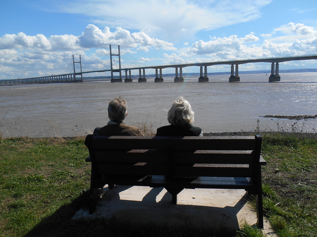
From Chepstow you can follow the Wales Coast Path for 870 miles (1, 370 km) to the border with England in the north. Two marker stones, one of local Pennant sand stone and the other of Halkyn marble from Flintshire, mark the start point near the Old Town Bridge not far from the castle. Here you can also see a ceramic map on the pavement depicting the whole of the Wales Coast Path and Offa's Dyke Path Trail.

At just over thirteen and a half miles (21.91km) the Path here provides a relatively easy walking experience with the only really steep parts in the town.

The Path leaves the bank of the Wye River, travels inland to meet the Severn Estuary then follows the sea wall to the picnic site at Blackrock. it carries on past the Victorian Severn Tunnel pumping station at Sudbrook and cuts through the Iron Age fort there.

The shoreline on the Severn Estuary is very important for wildfowl and some stretches are so valuable that the Path goes inland to accommodate them. The Path is carried on the top of the sea wall through continuous farm land to the border with Newport and on into the village of Goldcliff.


Chepstow to Sudbrook Section

Basic Directions
  • Follow the Coast Path symbols past St Mary’s Church, Chepstow, under the A48 underpass, past Tesco and the entrance to Chepstow Rail Station. Turn right then immediate left up School Hill. At the top of this steep section the Path passes through one of the old town gate ways in the medieval wall.
  • Turn left and follow the road signs along Garden City Way, Hardwick Avenue and Wye Crescent. The path passes the old Beaufort Quarry, Sunlight Textile Services factory and Bulwark Iron Age fort.
  • Joining the pavement at Victoria Road it’s down hill to Raglan Way with it’s views of both the Wye and Severn Estuaries. Carry on down a steep tarmac path following the rail line then up again into the woods of Warren Slade.
  • Follow the Path through to Parc Redding and carry on past the football ground and club house to join pavements again at Tenby Lane, Denbigh Drive and Caerwent Lane to go under the M48. Turn right immediately to skirt Newhouse Farm Industrial Estate with its views of the Severn Estuary (and glimpses of Asda warehouse to your left).
  • When the Path reaches the road, cross and continue on a well made path until you reach the fields of Innage Farm. (Dogs must be on leads across farmland). The Path goes straight through the first field then bears diagonal right after the 2nd gate to meet the fence line and a stile.
  • Turn immediate left and follow the fence line to the road and another stile.
  • The route then goes down the lane past the north side of Mathern Church and back onto farm land where you turn left through the first field then diagonal right to the gate into St Pierre Golf Course to cross a wooden pedestrian bridge.
  • The signs take you round two edges of the green then left over another wooden bridge. At the end of the bridge through the kissing gate immediately turn right going over a concrete farm bridge and through another metal kissing gate.
  • Cross the field passing Pill cottage on your right.
  • At this point turn left following the hedge line. (The metal kissing gate will take you onto the access road for the golf club house and hotel).
  • Cross the gated wooden pedestrian bridge and keep the fence on your right till you come to a metal kissing gate. You will see another metal kissing gate ahead which is often left on its own without fencing attached. Head towards that and passing through it, keep on heading in the same direction to the gates near the railway line.
  • This is a main line so care must be taken. Keep to the decking of the crossing and go out of the gates on the other side.
  • Keep the sea defence bank to your left and the field fence to your right. Follow the fence round a right hand bend.
  • Further along you will see a narrow ramp up the sea bank to the path on its top. (The shore nearer to the railway lines is a special place for wildfowl so the Coast Path avoids going immediately onto the sea wall.)
Picture
​Email: chepstowwaw@hotmail.co.uk 
Address: Chepstow Walkers are Welcome, c/o Fox and Hounds, Itton, Chepstow
​Monmouthshire NP16 6BX
 Tel: 01291 641856 or 07760 195320
Email Us
Picture
Picture
calendar
  • Home
    • Chepstow
    • Public Transport
    • Walk Responsibly
    • WAW Network
    • Support Us
    • About Us
  • Events Diary
  • Stay, Eat and Shop
    • Self Catering
    • Bed & Breakfast
    • Hotels and Hostels
    • Caravan and Camping Sites
    • Pubs & Wine Bars
    • Cafes and Restaurants
    • Shops and Services
    • Walking Holiday Providers
  • Walking in the Lower Wye
    • Chepstow Town Map
    • Wales Coast Path
    • Offa's Dyke Path
    • The Gloucestershire Way
    • Wye Valley Walk
    • The Monmouthshire Way
    • Chepstow Dell and Town
    • Devauden Loop
    • Lancaut Peninsula
    • St Tewdrics Way
    • Devils Pulpit
    • Mathern and St Pierre
    • Chepstow Riverside
    • Vedw Wood and The Cot
    • Shirenewton and Llanmellin Hillfort
  • Contact Us